I had not hiked the Waipio Valley in over a decade - and I had a never ending burning desire to hike in this remote and austere valley. I read about some of the majestic waterfalls that lay hidden deep in the valley - only to be seen by adventurous hikers. I zeroed my sights in on the famous Hiilawe Falls - a 1400 foot high waterfall at the back side of the Waipio. I had found very little information online about how to get to the famous waterfall - although I had seen many breathless photos of the famous landmark. I knew that hiking up to the waterfall would be a challenge. I barely remembered hiking into the valley as a kid - I had distant memories of the lush vegetation, crossing numerous streams, and the overall sense of undisturbed nature - the Hawaii of yesteryear.
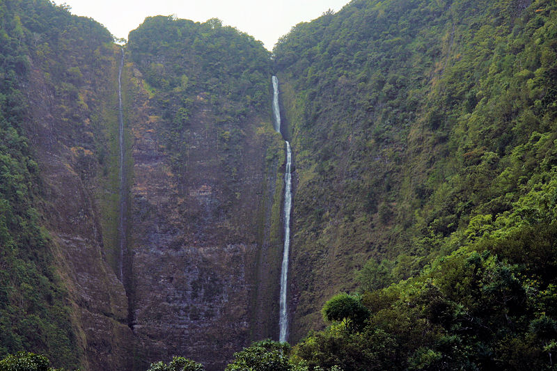
I studied a 1:24,000 topo map of the valley and even entered a few coordinates (including the location of the falls) into my GPS for situational awareness. Unfortunately, at the time, my Garmin 90 CSX GPS only had 1:100,000 topo maps available on it — hardly something I could use to navigate the densely vegetated Waipio Valley - at that scale, the so-called Topo map barely even depicted major trails - let alone the ones I would have to traverse to approach the falls. We loaded up on water and my camera and began our hike down the narrow switch-back road from the Waipio Valley Lookout to the valley floor below. The hike down provided a wide panoramic view of the Waipio Valley - as you hiked further and further down the road, you saw a more expansive view of the valley, the farm lands beneath, the black sand beach at the mouth of the valley, and the steep trail (called the “Z-Trail” by locals) scaling the north cliff face leading you over to the next valley, the Waimanu Valley. We spotted several hawks flying overhead, welcoming us to the valley. The hike down (and subsequently back up) is over a paved road, but don’t let that fool you - the grade is a steep 25-degrees and descends 900 feet in about half a mile - definitely nothing to sneeze at!
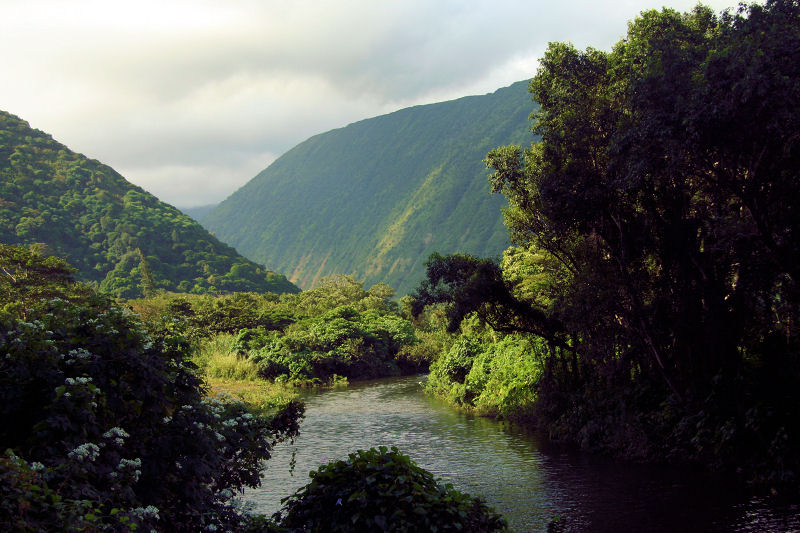
You could see small houses and primitive shelters used for farming taro in the fields below. A river winds its way through the middle of the valley - fueled by the heavy rains that are typical to this part of the Hamakua coast - the same water that feeds the plentiful waterfalls. Once we got to the bottom of the valley, we turned left (west) and followed a rough road towards the back end of the valley. Towering fruit trees line the road and the plant life was vibrantly alive - you could smell the freshness and fertility in the air. As the road neared its end, we caught glimpses of Hiilawe Falls in the background and we knew the general direction we needed to go. However, the road bends to the right (north) and continues away from the falls - so we needed to pick a point to leave the paved road and go “off-roading”. At this point we wandered down a path (left turn from the road) and ended up passing by several houses. Please be respectful and do not disturb the homes or their belongings. It is a bit sketchy here as to what is public and what is private land.
Right around here is where we met up with a couple from Seattle - they too were hiking and exploring the Waipio Valley. One of the people in our party tried to navigate us to the old abandoned “Tea House” - but he was going off of memory and without any prominent landmarks or map points on our GPS we wandered aimlessly for a short period among the foothills at the south-western edge of the valley. Eventually we all conceded that the old Tea House could not be found today and that we should continue to press for Hiilawe Falls.
We continued and the trail for the most part ended, but by using the GPS we knew the general direction to continue. This led us through a set of taro fields - which are much like rice paddies, water-soaked fields blocked in by man-made walls. Each of these divided taro fields was fed by naturally flowing streams or irrigate by a rudimentary collection of PVC pipes siphoning water from other nearby streams. We traversed the fields (careful not to leave a trace) and ended up paralleling a stream in the forest, while continuing to move to the northwest. Ahead, we could see the steep walls lining each side of this gorge closing in. There was a bend up ahead and around the vegetation and hillside, one could hear and see glimpses of the waterfall. We knew we were close!
We rounded this bend - moving to the left (west). Then the trail ended abruptly - in front of us was deep water at a bend in the river and on our left and right high, steep rocky canyon walls. We were at a bottle neck with nowhere to go but wade through deep water - my GPS said we were only 0.25 miles from the falls! A mere quarter mile from our goal and it looked unpassable - unless we waded through this deep water with our packs on and camera equipment to get wet, we wouldn’t get to the falls. We briefly contemplated what to do next - all this way we had come and we were so close to our goal.
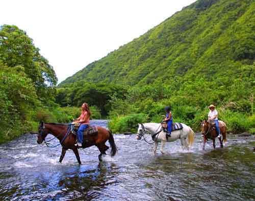
We decided to turn back and hike down to the black sand beach and enjoy the sights there, a little deflated, at least we saw the majestic Hiilawe Falls. At the beach we saw the mighty Pacific Ocean waves crashing on the shore. R ight here in the shade of the coniforous trees, wild horses grazed in the grass, oblivious to us. The raw natural beauty of the Waipio was incredible! We finally hiked back up the steep road back to the overlook passing groups of people beginning their journey into the grand Waipio.


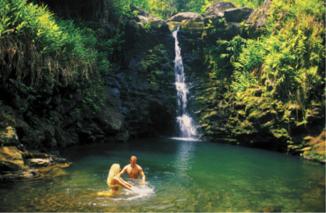


That’s exactly the same spot we turned back at. If I ever make it back, I plan to hike past the pool, always regretted never making it.
It is the most beautiful spot in the world!
After the fact, I am kicking myself for not continuing. Part of the reason was we had packs on and couldn’t have taken them with us over the water without getting everything we were carrying wet. Next time, we may have to ditch the packs or carry dry bags to keep everything dry (including our cameras!)
I agree with you - it was very regrettable that we did not make it all the way to Hiilawe Falls. It truly was serene and beautiful.
I went to Hawaii twice, the first time I had my no waterproof camera with me and i got to the cliff with the pools. I climbed the hills, got lost but somehow found my way to the ocean by the river. Two years later i
went to the same place, only this time i only brought some food and a water-proof carrying case for my camera. I swam through the pools, and after some really hard hiking, the last half a mile, i reached the waterfall. A VERY good book is Hawaii revealed:http://www.amazon.com/Hawaii-Island-Revealed-Ultimate-Guidebook/dp/0963942964
it is a really nice book that show some things we didn’t know about.
In conclusion, the only way you can get to the falls is to SWIM.
I’m heading to the big island in two weeks, and will be taking a dry sack thanks to your commentary. I’m curious though…does any of this hike go over private land such that I need to request permission from the owners?
Clinton
whoops i forgot one thing, if you are doing the hike you have to climb under some barbed wire. don’t worry, as long as you don’t make any LOUD SCARY noises, you WILL be fine. one more thing, we went there twice and didn’t see any people on the property. also when we got lost the first time, we strolled upon some random house which appeared to be deserted.
and no, no permission is required
You won’t require any permission for this hike. You may encounter cultivated fields and a few (sparse) homes. Once we left the paved road on this hike in search of the Hiilawe Waterfall, we didn’t see anyone other than two other hikers.
Please be respectful, though — don’t disturb anything and yes, I too had to navigate under one barbed wire fence too…
Good luck!
thanks for the information. What exactly is the issue with loud noises? I don’t really plan to make any, but it’s nice to know what to guard against.
Clinton
don’t go around throwing stick of dynamite or screaming swears over a megaphone. not that you would do that of course but local would probably not appreciate it. some people say locals aren’t friendly in that area. if there is any SLIGHT chance you see one, be friendly. if the guy starts yelling at you explain that you had no clue that this was private property and thought the barbed wire was out dated. i am talking about worst case scenario.
If you're wearing shorts or swimwear that can get wet, you can hold your pack over your head and easily traverse the pool. It was only chest deep, at least in July. The rest of the hike, while not too long, is still a bit of a challenge but if you stay close to the river, mostly on the left, you'll find some faint trail that will lead you to the pool under the falls.
However, closer to august, or when there is a lot of rain, it is hard to pass some places without swimming. Both times we were there we were forced to swim
Be careful when wading the stream from the end of the known trail. If the water is moving swiftly don’t go any further! If it just casually flowing your fine. Be aware of the weather forecast too. Flash floods in the valleys can be deadly. Best to have your gear in dry bags or even 1 gallon freezer ziplock bags. Body board will float your gear through the stream. Yes, be respectful of those who live in the area. No trash left behind.
After my first experience hiking to these falls, I now carry several dry bags in my pack. Yes, it is definitely important to keep a close eye on the weather when hiking in the valley - or when hiking at any location for that matter. The river here in the Waipio takes many forms depending on the rain that feeds it - heavy rains high up the valley walls inland can make this river swollen, fast moving, and uncrossable. Drought (like what I saw on my last trip to the Waipio) and the river is slow, calm, and can be crossed at certain points (we even saw several people lazily standing on paddle boards in the middle of the river!)
Mi girlfriend and I hiked to the Hi’ilawe falls this March. When we reached the big pool of water we were confused and decided to turn around. Luckily a couple of guys were coming back from the falls right there and then! They told us to walk (swim) through the neck deep pool of water and follow the trail (that zig-zags around the stream).
After crossing the pool we had some trouble following the trail, having to backtrack a couple of times and walking over some boulders, but at the end we made it! Definitely one of the best sights you can wish for.
Before coming back my girlfriend became my fiancee….
First, let me say congratulations on the engagement! From your comment, I really wish I had pushed on to the falls! I recently was back in the Waipio Valley - but this time we drove down instead. As we drove to the northwest (deeper into the valley) I could once again see Hi’ilawe Falls in the distance and all I could think was my failed attempt at reaching it. Did you guys drop off your gear at the pool of water to keep them dry?
One thing I wanted to point out - there is a great book store along the Hilo waterfront called “Basically Books” where you can get full topographic map coverage of all of the Hawaiian Islands (1:24K USGS). After my Hi’ilawe Falls attempt (using the deficient 1:100K maps on my GPS), I went to this book store and got topo maps of the northeast coast of the Big Island from Pololu all the way to Waipio and had the store laminate them for me. Now, I have great coverage of the most topographically amazing part of the island — these maps show all of the trails and dirt roads to a very good level of detail. Basically Books can be found at 160 Kamehameha Avenue, Hilo, HI 96720-2834 (808) 961-0144.
We just removed our T-shirts (we both had swimming suits) and walked through the pond. I held my backpack (not water proof) over my head. It was a little tricky because there were several big slimy rocks on the floor of the pond; a couple of times I lost my balance and had to “swim” for few seconds keeping the backpack out of the water.
Few pointers:
1. Best way to cross the pond is to enter on the left side and cross diagonally (staying on the right side of the big rock in the middle). The best place to exit the pond seems to be the right most corner.
2. We think that it is basically impossible to avoid the boulders. Since everything is wet there is some potential danger there.
3. After crossing the pond one stays on the right of the stream for a while. Then one is forced to cross back and fort few times (the boulders are on the left side). The last stretch is on the right side. Footprints in the mud can be a useful tool to identify viable paths.
Good luck!
I red in the Lonely Planet about a treehouse run as a hotel. I tried to find it - in vain. I ate huge honeysweat grapefruit. I saw a lot of table: beware of the dog, I have not seen any. The waterfall allways the best wiew from a distance. I saw some car wreck in the road down. 40 50 years old! And I could not take any pictures becouse the poor light conditions. Waipio Walley is the secret paradise in Earth. I feel lucky to see it.
if anyone has pictures on those car wreck, please send me ([email protected]).
Great description of the hike, and sounds like a crazy adventure. Can you tell me about how long the hike is to the falls (assuming you are able to cross the pond/river)? We are thinking of making the trek but aren’t sure how early we will get started, so are interested whether it is a few hours or more?
We are fit, so that’s not a big issue…just how long.
Steve,
The last time I did this hike we left Hilo around 7AM. We hiked down into the Waipio, to the pond / reservoir near the falls and then all the way back to the overlook by just after lunchtime.
SO love Waipio Valley!!! First time there was in the 70′s. 2003, dropped my camera in a stream . . . lost some incredible scenes after hiking deep into the valley!
Cathy,
I recall the first time I ventured into the Waipio - it was with my father probably 25 years ago or so… we hiked down into the valley, then across the valley floor fording several rivers and wandering deep into the thickly-forested areas. The vastness and isolation of the valley struck me then. Since then, I’ve hiked down and driven down into the Waipio. And I look forward to going back once more very soon - and hopefully accomplish my goal of reaching Hiilawe Falls next time!
I hiked down and back today…it”s really awesome. Was worried that it’d be too much for me since I”m 40 like beer too much and like tobacco too and haven’t done something like this since Huanay Pichuu 13 years ago but it wasn”t bad at all. Made it down in 20mins w stopping to take in the view, my legs burned and shook but…and 30 mins back up, 1 step at a time. some of the blog posts almost made me hesitate, just do it. well worth the burn. falls awesome, beach beautiful. would like to do an overnight now and hike through more than 1 valley…maybe even take on the Z SB
@Senorbad, Thanks for the hiking update.
I absolutely agree with you - “well worth the burn”! Did you see any wild horses? Last time I went, the wild horses were nowhere to be seen…
What I’ve always wanted to do was kayak from the Waipio black sand beach over to Waimanu Valley. Unfortunately, there is the logistical challenge of getting your kayaks down into the valley. And, due to the rough waters, you can only do this during some of the calm summer months. Apparently, it is a popular thing to do Memorial Day Weekend (a few weeks ago).