Road to the Sea
The Chain of Craters Road in Hawaii Volcanoes National Park, leads you from the Crater Rim Drive, zig-zagging down the side of the Kilauea Volcano, all the way down to the ocean and eventually ending at the site of the current active lava flow.
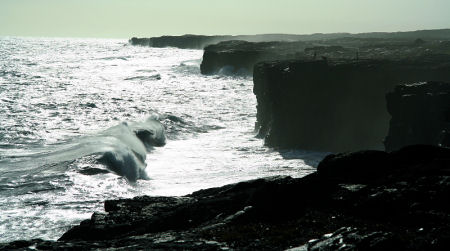
 Lava sea cliffs |
 Sea cliffs, Chain of Craters Road |
 View of Coast Below |
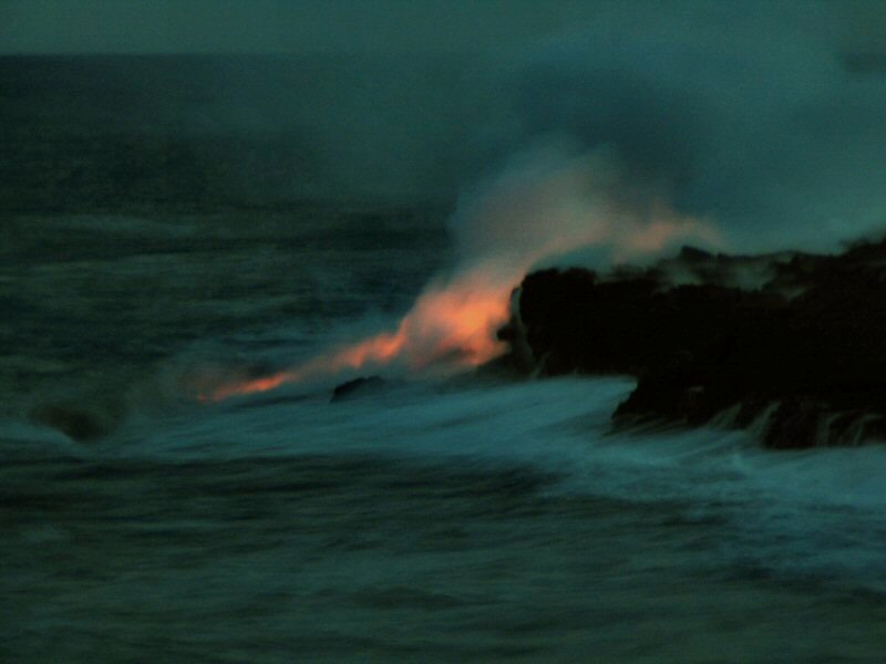
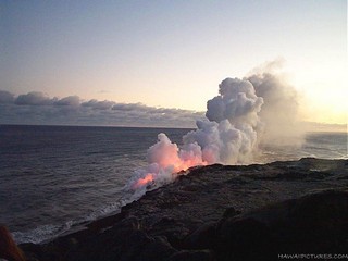
 Lava flow ocean entry |

Holei Sea Arch
If you have three to four hours to visit the park, you should take the time to explore the East Rift and coastal area of the Park via Chain of Craters Road. This road descends 3,700 feet in 20 miles and ends where a 2003 lava flow crossed the road. Dependingon changing volcanic activity, there may be opportunities for viewing active lava flows from the end of the road. No food, water, or fuel is available along the Chain of Craters Road. There are spectacular views of the coastline from various scenic points on this road. Once you reach the coast, you will see the powerful waves pounding the lava sea cliffs sending water spraying high into the sky. The road ends at a parking area where you can hike to see the active lava flow. Lava flows and viewing conditions change daily, so please consult the visitor’s center for the latest information.
Near the end of the Chain of Craters Road is the Holei Sea Arch. This natural bridge was formed by the destructive force of the rough ocean waves carving away at the lava cliff. You can park your car nearby and walk across the dried lava beds to view the sea arch and the crashing waves below.
Photo contribution by Tony Braim
Chain of Craters Road originally connected Crater Rim Drive to Makaopuhi Crater and was completed in 1928. In 1964, the road was extended to Kalapana. Lava flows from the Mauna Ulu eruption closed Chain of Craters Road in 1969. The road was reopened to 1979. In 1986, lava from the current eruption of Kilauea closed the road. At the present time, Chain of Craters Road is about 20 miles (32 km) long and 7.5 miles (12 km) of the road has been buried by lava.
 Steam from lava ocean entry |
") Napau Crater Trail (Mauna Ulu) |
Chain of Craters Hiking Trails

Kilauea lava flow overruns road
Several Trails begin on the Chain of Craters Road. One of the most dramatic trails is the Napau Crater Trail starting at the Mauna Ulu Parking area. Initially this trail leads you to the top of Pu’u Huluhulu and continues past cinder cones, pit craters, and a tree fern rain forest to the edge of the Napau Crater. The Hilina Pali Trail trail starts at the overlook at the end of the Hilina Pali Road which branches off of the Chain of Craters Road. This trail switchbacks steeply down to the coast to Kaaha Point on the coast, about 7.5 miles round trip. The Pu’u Loa Petroglyphs trail is also located off of the Chain of Craters Road. This is an easy hike to Hawaii’s most extensive petroglyph fields.
Check out the Hawaii Volcanoes National Park Map to help you plan your trip.
Take a Virtual Tour of the active Kilauea lava flow
View our lava flow photos and our volcano videos.
Hawaii: The Big Island Revealed
 The Ultimate Guidebook by Andrew Doughty may properly be placed among the greatest guidebooks of Hawaii. Enhanced with 39 color maps, 132 color photos, and all the secrets necessary to fulfill the desires of any tourist. Andrew Doughty enlightens the reader on the every given shop, hotel, beach and cafe that only a Hawaii native might recognize for the exceptional decency or beauty of. Strongly recommended read for travelers planning a trip to Hawaii (or for those unsure where to go once they have arrived), Hawaii: The Big Island Revealed will help to make your destination Hawaii.